|
LOCATION AND PHYSICAL FEATURES OF THE LAND
LOCATION:
The island municipality of Mapun is situated at the western part of the Mindanao Peninsula. To its northwest is the Palawan
Peninsula, and to the south is the federal state of Sabah, Malaysia. Its coordinates are Latitude 6.9767 Lat (DMS) 6° 58'
36N and Longitude 118.5136 Long (DMS) 118° 30' 49E.
Mapun is approximately 163 miles northwest of Bongao, the provincial capital of Tawi-Tawi. It is 220 miles west to Zamboanga
City and only 69 miles north of Sandakan town of Sabah, Malaysia.
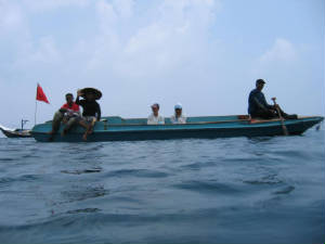
The island municipality can be reached by air or sea transportation from existing travel points Zamboanga City, Bongao,
and Brookes Point Palawan. While there is no regular commercial flight to the island, air transportation is possible through
once-a-month official trips of the Philippine Air Force from Zamboanga City. Sea transportation is provided by seven sea vessels
regularly traveling the Mapun-Zamboanga City and vice-versa route. Sea travel time from Zamboanga City usually takes more
than 27 hours while from Bongao, Mapun is reached within 20 hours. Mapun-Palawan via Brookes Point sea route takes 14-15 hours
using motor launches. Privately-owned small motorboats in Mapun could travel from the island municipality to Sandakan, Sabah
Malaysia in 8 hours while fast sea crafts like speedboats could ferry passengers to the place only in 2 hours time.
TERRITORIAL WATERS:
Many of the Jama Mapun or the natives of Mapun use their own traditional concept of territorial waters. Under this rule,
the territorial waters of the municipality extend far beyond the 15km-limit set by the Local Government Code of 1990 to as
far as Taganak and Mangsee Island to the south and to Cagayancillo Island up north. This claiming of territorial waters surrounding
Mapun as part of Mapun territory is due to hundred of years of geographic isolation and intense exploration, fishing and trade
that brought about its own set of territorial rules.
CLIMATE:
The island municipality is classified under the 4th type of climate having distinct dry and wet seasons and is characterized
by evenly distributed rainfall throughout the year. Heavy rains occur during the months of August to November. March and April
are the hot summer months when most water sources in the highlands of the interior dry up. The island however has a normal
average rainfall.
All types of winds reach the island from different directions at different times of the year. The most notable types due
to their regularity are the following:
Southerly wind (Sa-atan): June - October
Westerly wind (Balat): June - October
Northerly wind (Uttarah): December - April
Northeasterly wind (Timulaut): December - April
Travel advisory suggests the month of May as the best month to travel to and from the island when the winds and the sea
are calm.
TOURISM
Tourist Attractions (Natural and Manmade):
There are 26 mountains on the island, the highest peak being Mt. Liran (1,105 ft. above sea level), which is sprawled
over the barangays of Guppah, Duhul Batu and Sapah. But the interior of the island is a vista of "low and graceful green
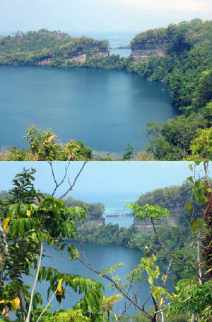
hills and cones rising from sloping valleys and miniature plains" that would be in itself a tourist attraction. -Found
some 40 feet above sea level, the Tow Lakes are nearly perfect circles, separated only by a few meters of solid rock is one
scenic view that would also attract visitors once developed.
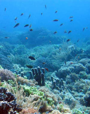
Mapun is also home for turtles. Turtles lay eggs in San Miguel Island, fondly called by the natives as Bangkawan. White
sandy beautiful beaches like Umus Beach, Billat Beach, Secret Beach, Raymond's Beach and Joker Beach offer colorful coral
reefs for picnickers and scuba divers.
Mapun has three (3) lakes, namely, Lake Danao, Lake Singuang and Lake Sapah with areas about 24, 28 and 69 hectares respectively.
Lake Danao and Lake Singuang are two freshwater crater lakes. Lake Sapah found near the center of the island is marsh-like
and formed by the accumulation of rainwater over time and is approximately 69 hectares in area.
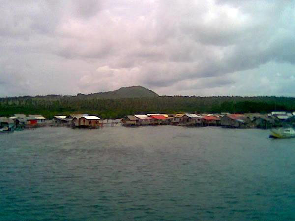
Jurata Bay, which was used as harbor by American warships and vessels during World War II, is one historic place and has
an area of about 35 hectares with about 70 fathoms at its deepest. A crater bay whose seaward walls open to the sea that forms
it.
Tourist Accommodations:
Mapun is a young local government unit in terms of development and progress. Tourists and visitors arriving in the island
are usually accommodated in private houses in the absence of commercial accommodation facilities.
Tourist Arrival
Most visitors that come to Mapun are with official purpose. Many are representatives of donor institutions that come to
the island by boat via Palawan. Occasionally when the weather is good, foreigners come and visit the beautiful beaches surrounding
the island that are conducive for scuba diving.
Accessibility:
Mapun is reached from Zamboanga City by boat during good weather. There is no regular schedule for sea transportation;
availability of transport facilities depends on the weather, volume of cargo and number of passengers. It is reached also
passing thru Puerto Princesa, Palawan from Manila by airplane or boat, and then takes the regular transportation from Puerto
Princesa to Mapun.
Communication facilities have been a difficulty when one is in Mapun. Commercial communication companies have not reached
the area yet. The local government looks forward to the availability of fast communication facilities that would make information
dissemination easier and faster.
 |
|
|
Jurata Bay View
|
What a Sight!
The most remarkable feature of Mapun is the two freshwater crater lakes (Danao and Singuwang) and a crater bay whose seaward
walls opens to the sea to form Jurata Bay. Found some 40 feet above sea level, the two lakes are nearly perfect circles, separated
only by a few meters of solid rock. Another lake called Sapah Lake is found near the center of the island. It is marsh-like
and formed by the accumulation of rainwater over time and is approximately 69 hectares in area.
|
|
|
|
|
 |
|
DEMOGRAPHIC PROFILE
Population:
Mapun has a total population of 22,011 according to the census conducted by the NSO in 2000. Local officials however have
disputed over the figure because it failed to consider the seasonal migration pattern of the labor sector in the area. A sizeable
number of highlanders briefly migrate to Sabah, Malaysia for seasonal job opportunities where they return to the island immediately
after within the year of their departure. The registered total number of household population is 21,999, lower than the total
population by 2 while the number of households is registered at 3,492.
Mapun is predominantly a rural community. Of the 15 barangays in the island, adjoining barangays Liyubud (Lower Lupah
Pula) and Lupah Pula (Upper Lupah Pulah) are the only two barangays classified as urban areas while the remaining 13 are rural
barangays. Most of the population or 82.6% are living in the rural areas or in their farms while only 17.4% or 3,843 people
are living in the urban areas. In terms of households, 2,914 or 83.4% are located in the rural areas. Only 578 are situated
in the center of the municipality.
Ethnic Affiliation:
The largest ethnic group is the Jama Mapun or the original inhabitants of the island where the local dialect Pullun Mapun
remains as the predominant dialect being used. Other ethnic groups comprise the Sama Badjao, Pangutaran (Sulu), Tausug (Sulu),
Yakan (Basilan) and a few others from Luzon and Visayas. It is of note however that in the Poblacion comprising the barangays
of Liyubud and Lupah Pula, Bahasa Tausug is the dialect widely spoken. Siyama (Badjao dialect), Pangutaran, Cebuano, Chavacano,
Illongo, Bahasa Malaysia or Malayu, English and Tagalog are also spoken on the island.
Religious Affiliation:
Over 90% of the population professes the Islamic faith. The rest are Roman Catholics, Protestants, Seventh Day Adventists,
Jehovah's Witnesses and other faiths.
Traditional Cultural Activities:
Mapun is rich in culture and tradition. The local government plans to revitalize and preserve the traditional arts and
culture of the Jama Mapun. This has been shown in dances and rituals done during Muslim and municipal-wide festivities. The
youth has also been trained and developed to love and preserve the culture of his ancestors even if they are in other places.
|
|
|
|
|
|
|
|